skip to main
|
skip to sidebar
Summer's GIS map catalog
Friday, July 25, 2008
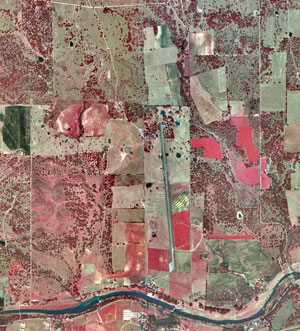
aerial photo (infrared)
http://www.nps.gov/lyjo/naturescience/naturalfeaturesandecosystems.htm
This photo is an infrared and aerial (overhead) view of a river valley in Texas. This area is part of the Lyndon B. Johnson National Park (ranch district). The infrared image colors help us determine which parts are certain agriculture regions, etc.
No comments:
Post a Comment
Newer Post
Older Post
Home
Subscribe to:
Post Comments (Atom)
Blog Archive
▼
2008
(49)
►
August
(32)
▼
July
(3)
aerial photo (infrared)
aerial photo (black and white)
cadastral map
►
June
(9)
►
May
(5)
About Me
Summer
View my complete profile
No comments:
Post a Comment